


ted to waleshome tp jim

frank b
User
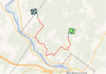

Length
8.7 km

Max alt
238 m

Uphill gradient
165 m
Km-Effort
11 km

Min alt
136 m

Downhill gradient
193 m
Boucle
No
Creation date :
2023-03-11 22:20:36.676
Updated on :
2023-03-11 23:06:11.675
45m
Difficulty : Very easy

FREE GPS app for hiking
 SityTrail
IGN / Geographical institutes
SityTrail World
The world is yours!
About
Trail Snowmobile of 8.7 km to be discovered at Quebec, Le Val-Saint-François, Canton de Cleveland. This trail is proposed by frank b.
Positioning
Country:
Canada
Region :
Quebec
Department/Province :
Le Val-Saint-François
Municipality :
Canton de Cleveland
Location:
Unknown
Start:(Dec)
Start:(UTM)
721787 ; 5063783 (18T) N.
Comments
Trails nearby